South Colony Lakes Hiking Trail, Colorado
Distance: 9.08 miles round trip. Elevation change: 9,931 ft to 11,709 ft
Time to Lower South Colony Lake: 2 hours 40 minutes
Time back to parking area: 1 hour 30 minutes
Total hike with stops: 6 hours
The South Colony Lakes trail is located south of Westcliffe, Colorado in the Sangre de Cristo mountain range. We hiked up to the Lower Lake during Labor Day weekend in 2014. Many people use the area around the lakes as base camp for summiting several peaks in the area including Humboldt Peak and the Crestone Needle.
There are two main parking areas for the South Colony Lakes Trail. A lower parking area at the base of the mountains on South Colony Road is suitable for non 4WD vehicles. The upper parking area at the trailhead is about 2.75 miles up the road. Low clearance vehicles should park in the lower parking area. We drove a Jeep Grand Cherokee to the upper trailhead. We saw a couple of Subarus at the upper trailhead and were amazed that they made it. The road in general was fairly rough and there were a few sketchy spots. There is one hole in particular that you must be careful navigating otherwise you could really mess up your underside. And on the way back, you can’t see where you’re going when you get to that spot.

Looking up the road to the upper trailhead at one of the sketchy spots
There were plenty of vehicles when we arrived around 8:45am, but we still managed to find a spot. The trail heads into the woods and crosses a bridge before heading up an old Jeep road.
Trailhead at the upper parking lot. Trail starts on the left side of this picture.
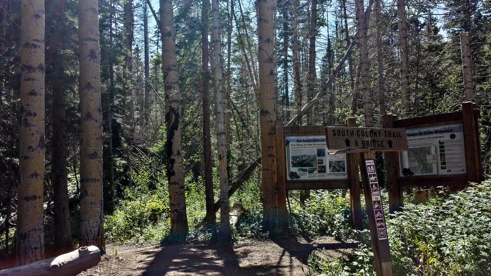
The trail follows the old Jeep road for about 2.6 miles before reaching a split where each trail narrows. The Jeep road is steep and rocky so sturdy and comfortable shoes are recommended. Once at the split, you can follow the sign to the left or right. We chose to go to the left since we weren’t familiar with the trail and the sign indicated that the Lower Lake was to the left.

From the trailhead, we reached the trail split side after about 2.58miles. We went left to the Lower Lake. From what I’ve read, you can get to the Lower Lake in potentially less time by taking the right-hand loop.
Less than 0.2 miles after the split, we came to a red gate with a sign that read that the Lower Lake was 1.5 miles away. The trail levels off for a while and doesn’t climb much until it nears the lake. The scenery opens up not too far after the red gate with sheer mountain walls all around.

From the trailhead, we reached this red gate after 2.74 miles. The sign says 1.5 miles to the Lower Lake from here. It was pretty accurate.

The trail curves around the mountain before heading uphill as it approaches the Sangre de Cristo Wilderness.

Rounding one of the mountains to head up to the Lower Lake

We reached the Sangre de Cristo Wilderness sign after 3.87 miles
The trail climbs up through the forest and begins following a steep drop off where the views open up to the Crestone Needle. The trail continues up through the trees before reaching the lake. There is another fork right before the lake. Going left will take you along the south shore of the lake toward the Crestone Needle trail. Going right will take you around to the north side of the lake and head towards the Upper Lake. We first went to the right and explored a bit before ending up on the south side of the lake.

Our first view of the Crestone Needle
Canon 6D, Tamron 24-70mm
ISO-100, 24mm, f/8.0, 1/200 sec

Crestone Needle towering above Lower South Colony Lake
Canon 6D, Tamron 24-70mm
ISO-100, 24mm, f/8.0, 1/200 sec

One of the outflows at Lower South Colony Lake. It can get pretty windy up there as evidenced by the trees!
Canon 6D, Rokinon 14mm
ISO-100, 14mm, f/8.0, 1/160 sec

Lower South Colony Lake
Canon 6D, Rokinon 14mm
ISO-100, 14mm, f/8.0, 1/200 sec

As we walked around the lake we saw several empty campsites and a few with tents set up. Many of the campsites were tucked away and sheltered by shrubs. After over an hour at the lake, we started the trail back down. We took the same trail that we came in on. The rocky Jeep road was a bit rough on our feet going down particularly because we were traveling much faster. On our way down we passed a climber that we saw earlier coming down from the Crestone Needle. He looked pretty worn down, was traveling alone, and carrying his helmet. We felt bad for him so tried to exchange some encouraging words as we were only about half a mile from the parking area at that point. Luckily he hadn’t parked down at the lower parking area!
South Colony Lakes is well worth the hike. It’s a beautiful area surrounded by towering peaks. It’d be nice to do a weekend backpacking trip up there. There are so many areas to explore and plenty of campsites tucked away. We will be visiting again someday!

Back at the packed parking lot. We made it!